Upper Shasta RIver Assessment
The SVRCD is actively collecting basic information about irrigation diversions in the Upper Shasta River watershed. Letters were sent out to more than 70 of the 300 plus landowners to gather details of irrigation ditch diversions in Carrick, Boles, Beaughton, Dale, Eddy Creeks and the Shasta River above Dwinell Dam in the Edgewood and Weed reaches.
The project is designed to collect data for future diversion improvements including fish screens, headgates, weirs and staff gages where needed. Many ditches serve multiple properties and are managed with the help of the Scott-Shasta Watermaster.
Once the assessment is complete, funding will be sought to work with willing landowners to improve their headworks. These improvements will protect important ecological, cultural, and sport fishing species that are present in the Upper Shasta River and its tributaries. California Department of Fish and Wildlife is funding this work. If you would like to participate contact SVRCD at 530-572-3120.
Ltr to Landowner_FINAL.pdfFrequently Asked Questions_FINAL.pdf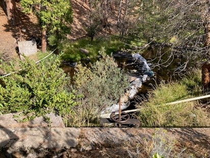
Typical Diversion in the Upper Shasta River Watershed. Steep topography characterizes the area with diversion ditches serving multiple properties that have subdivided in the recent past. Good water quality from springs on Mt. Shasta contributes to the overall inflow to Lake Shastina.