Irrigation Efficiency Improvements with CIMIS
In order to help understand what sustainable ground-water use looks like in the Shasta Valley groundwater basin, a groundwater model is being developed. The model will account for all of the water that moves in and out of the Shasta River Watershed. The input is primarily precipitation and the outputs are primarily stream flow out to the Klamath River, and evaporation and transpiration (ET) of crops, plants, and forests.
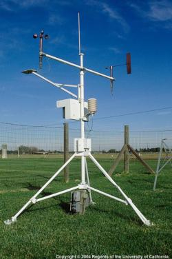
The RCD has been working for the past two years with the DWR’s California Irrigation Management Information System, or CIMIS, in order to measure the amount of water lost through the process of ET. The Shasta Valley is now home to two CIMIS stations that measure precipitation, wind, temperature, humidity, and solar radiation and calculate rates of ET. The CIMIS stations are located on irrigated pastures to get the most representative measurement of ET across the basin.
The benefit of CIMIS to agriculture is that these data can help inform irrigation scheduling, which can lead to conserving cash and water at the pump or at the head-gate. Because the Shasta Valley has many microclimates, it is recommended that each stakeholder install a rain gauge at their own residence or field and compare with what is being recorded by the nearest CIMIS station to obtain the most accurate ET data.
The two Shasta Valley CIMIS stations can be found here: CIMIS (ca.gov)
Montague Station ID 260 and Gazelle Station ID261.